Delivering ocean insights, preserving data for the future
Sharing Your Data: Transitioning to WIS 2.0 for Enhanced Data Management and Flow
Real-Time Data Sharing with WIS 2.0
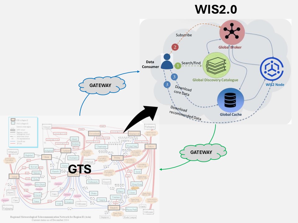
The World Meteorological Organization (WMO) has introduced the WMO Information System 2.0 (WIS 2.0) to modernize and streamline global data sharing. WIS 2.0 addresses the limitations of previous systems by leveraging the public Internet and employing a publish-subscribe model using the MQTT protocol. This design allows users to subscribe to specific topics and receive real-time data updates efficiently.
For data buoy operators, this means that platform sensor data sent via satellite can be decoded, processed into geophysical units, quality-controlled, and disseminated in real time through WIS 2.0. This ensures that data users have timely access to accurate and reliable information.
For decades, the Global Telecommunication System (GTS) has served as the cornerstone of meteorological data exchange, enabling the World Meteorological
Organization (WMO) and its members to share critical weather, climate, and environmental data through dedicated private links. However, rapid
advancements in digital technology, coupled with the growing demand for real-time, accessible, and voluminous data across diverse WMO
disciplines, have necessitated a modernized approach.
The WMO Information System 2.0 (WIS 2.0) is poised to replace the GTS, leveraging the public internet and a publish-subscribe model powered by the
MQTT protocol to deliver efficient, cost-effective, and inclusive data sharing. Unlike the GTS, which relies on specialized infrastructure,
WIS 2.0 enables data publishers to operate WIS2 Nodes, allowing users to subscribe to specific data topics and access real-time updates via
HTTP(S) downloads, supported by Global Services such as Global Brokers, Caches, and Discovery Catalogues.
This transition, approved by the Commission for Observation, Infrastructure and Information Systems (INFCOM) in October 2022, is well underway,
with a pilot phase in 2023, a pre-operational phase in 2024, and full operational status targeted for 2025, after which WMO Members are
required to migrate. The WMO’s “WIS2 in a box” software further democratizes participation, particularly for Least Developed Countries (LDCs)
and Small Island Developing States (SIDS), ensuring no member is left behind. For detailed insights into the GTS and the structured timeline for
this transformative shift, visit the WMO’s WIS2.0 page
overview.
Near-Real-Time and Archived Data Access
Canada's Integrated Science Data Management (ISDM) center archive buoy data on behalf of the Data Buoy Cooperation Panel (DBCP) and the
Global Ocean Observing System (GOOS), making it available for historical analysis typically within two months of observation. Similarly, the
Coriolis Data Center offers comprehensive access to in-situ oceanographic data, including both real-time and delayed-mode datasets,
facilitating a wide range of ocean research and operational activities. These archived datasets are invaluable for long-term climate monitoring,
environmental assessments, and the validation of oceanographic models, ensuring a robust understanding of ocean dynamics over time.
Assistance for Data Providers
The DBCP Task Team on Data Management are available to support data buoy operators and data centers in sharing their data through WIS 2.0.
This assistance ensures that data providers can effectively contribute to the global data pool, enhancing the overall quality and
availability of meteorological and oceanographic information.
Data Formats and Communication
When considering data formats within WIS 2.0, there are two distinct stages in the data flow:
Communication between the platform and the satellite (and data processing center): This involves transmitting raw data from the buoy to the satellite and subsequently to the data processing center.
Communication from the data processing center to data users: In WIS 2.0, this is facilitated through the publish-subscribe model, where processed and quality-controlled data is published to specific topics, allowing users to subscribe and receive updates in real time.
By adopting WIS 2.0, data providers and users benefit from a more flexible, powerful, and easy-to-adapt system that supports the growing demand for high-volume, high-velocity, and diverse data across all Earth-system domains.
Table-Driven Code Forms (TDCF) for Buoys
BUFR Templates for Buoy Data:
BUFR template for moored buoys: TM315008
BUFR template for drifting buoys: TM315009
BUFR/CREX templates for tsunameter data and DART buoy system messages: TM306027
Transitioning to WIS 2.0 represents a significant advancement in global data sharing, offering enhanced efficiency, accessibility, and support for data providers and users alike.